WALL challenges Ofgem to look again
This was not about the merits of the project overall, but about the rules that decide how much extra time LionLink can have to get built, and what happens if it is late. LionLink would be supported by Ofgem’s “cap and floor” scheme. If the project earns less than an agreed minimum, the shortfall is topped up and that money is recovered through charges that end up in electricity bills. That is why the economics matter to everyone, not just to people who live near the route.
The consultation closed on 15 October 2026. WALL has analysed the underlying economics of LionLink and, based on that work, sent Ofgem a detailed response on 13 October 2026. This note explains, in plain terms, what we have said and why.
What do Ofgem’s own figures show?
Ofgem’s own figures show British electricity consumers losing out. In November 2024, Ofgem’s own assessment found losses to consumers in every one of the three main scenarios it examined: between £3.1 billion and £6.1 billion over 25 years. These are not the same as a rise on your bill, but they show who loses out.
The project only looks positive because others gain more. Electricity generators and the link’s owners gain more than consumers lose, leaving a small overall surplus of £0.3 billion to £1.2 billion.
The numbers are unstable. In just eight months in 2024, Ofgem’s estimate for consumers in one scenario swung from a £3.5 billion gain to a £3.1 billion loss.
Local costs are not counted. Ofgem’s figures do not put a value on the harm to the protected Suffolk coast, including the Minsmere-Walberswick wildlife sites and the Suffolk and Essex Coast and Heaths National Landscape, or on tourism, local businesses, access to nature, and health and wellbeing. A surplus as small as £0.3 billion could easily be outweighed by costs that have not been counted.
What has changed since?
Ofgem assumed LionLink would start running in 2030. The rules now allow it to start as late as the end of 2035, in an energy market that may look very different.
National Grid has changed its plans again, proposing a third landfall site in Walberswick.
The government has asked for more information on Sea Link, the other major cable projecton this coast, after its public examination closed.
A new national energy plan, setting out what energy Great Britain needs and broadly where, is due in autumn 2027. LionLink has not been checked against it.
The National Audit Office has called for stronger oversight of how major grid projects protect bill payers.
What is WALL asking Ofgem to do?
1. Look again at whether LionLink still makes economic sense, using today’s evidence and taking into account the costs to local communities and the environment, and publish the result.
2. Explain what LionLink could mean for household and business bills, and who carries the risk if things go worse than expected.
3. Check LionLink against the new national energy plan before giving it more time or its final approval.
4. Build a proper check into the rules, so that a project’s case is tested again whenever circumstances change.
5. Make the 2035 deadline a real deadline, with no extensions beyond it, even for events outside the developer’s control, so that consumers are protected if the case for the project changes.
6. Be open about its decisions and the reasons for them.
Where should LionLink connect?
WALL has always said that if LionLink has to come ashore, it should connect at an existing brownfield site, not in a small stretch of the Suffolk coast already crowded with energy projects. On the Dutch side, the cable is routed along existing waterways to an established energy hub. Suffolk deserves the same care.
Find out more
Ofgem, the energy regulator, has just run a consultation process about LionLink.
reasons why the LionLink proposal is wrong…
-
Walberswick is a high value tourist village with protected habitats and one fragile access road, and I strongly object to it being used as a landfall site.
Walberswick has one of the oldest populations in England: 43% are 65+, 11% are 85+ yet NGV has not assessed impacts on older residents or complied with the Public Sector Equality Duty.
Walberswick is an economically vibrant village that is totally dependent on tourism. It has a number of businesses, including pubs, cafés and shops that will be severely impacted by these plans.
-
I strongly object to the revised landfall site G3 — it’s surrounded by homes and sensitive habitats and is completely unsuitable.
I reject the proposed working hours: 12hour days, 7 days a week, for up to 2 years, plus 24hour HDD drilling is unacceptable for any community.
There’s no proper assessment of noise, lighting, vibration or HDD “fracout” risks.
No seasonal protections for wildlife have been included.
Key details about the construction compound are missing, so I cannot judge the true impact.
-
I object because the B1387 is the only road in and out of the village and cannot cope with HGVs — closures or significant restrictions would seriously affect residents, tourism and emergency access.
NGV has not produced any data on traffic levels, routing, vehicle types or congestion.
There’s no detail on haul roads or vibration impacts.
I reject the inclusion of village roads and key footpaths in the Draft Order Limits.
-
I object because the construction noise, 24hour drilling, vibration and dust will affect people’s welfare and mental health.
No windtriggered dust controls have been proposed, despite this being an exposed coastal area.
There’s no detail on nighttime lighting or how it will affect dark skies or wildlife.
-
I object to the major disruption and diversions to wellused footpaths that the PEIR itself admits will occur.
These are not minor recreational routes – they are heavily used public access corridors that form part of the daily life and identity of the village.
Key routes to the Marshes, beach, Spong Bridge and Dunwich are all within the Draft Order Limits.
No diversion plans or safety measures have been provided, which is unacceptable.
-
I object because the PEIR is missing basic wildlife surveys and NGV’s plans will cause significant harm to reptiles, marsh harriers, nightjars, redthroated divers, bats and key invertebrates.
Seasonal restrictions clash with each other, making proper ecological protection impossible.
The risks to SPA species and linked habitats haven’t been properly assessed.
I reject Walberswick as a landfall site as it will cause irreparable damage to protected habitats and SPA species.
-
The cable route could cut straight through an area of national archaeological importance.
There has been no proper assessment of the medieval harbour or ancient village remains and the routing and impact of HDD drilling.
I reject any approach that treats significant historic remains as disposable — they should be protected.
-
I object to and reject these proposals because the whole Sea Link + LionLink plan just doesn’t make economic sense and goes against modern energysystem thinking.
I’m concerned that no proper assessment has been done of better options like offshore grids or brownfield sites such as the Isle of Grain or Bradwell.
Adding LionLink on top of Sea Link would only bring more traffic, disruption, stress and longterm damage to a coastline that depends heavily on tourism.
I reject the idea of putting huge converter stations and an expanded Kiln Lane substation in Friston and beside Saxmundham — it would industrialise the area completely.
-
I object to the proposals because the PEIR doesn’t provide a meaningful cumulative assessment of all the energy projects affecting the Suffolk coast line including Sizewell C, EA1N, EA2, SeaLink and the proposed water reservoirs and pipelines for Sizewell C.
Most of the analysis has been pushed to the Environmental Statement, leaving the public unable to understand the full picture.
There’s no joined up mitigation plan, even though Suffolk is already overloaded with major energy projects.
If you want to help us in any way or have any questions, please contact us on: info@wall-update.org
Help Us Raise Funds
Running the WALL campaign costs money!
If you are worried about the threat that LionLink poses to Walberswick and are able to help by making a contribution to WALL please donate here
Our Mission
WALL wholeheartedly supports the UK’s commitment to achieve Net Zero by 2050 and recognises the importance of renewable energy to achieving that goal.
However, WALL believes that National Grid’s proposal to land their LionLink interconnector cable on the Suffolk coast is driven primarily by reducing costs and boosting their profits.
It will result in irreparable damage to the beautiful natural environment surrounding Walberswick, reduce biodiversity and harm local businesses and the economy.
WALL opposes LionLink and believes that the best solution is for National Grid to create an offshore grid and bring cables ashore at an existing brownfield site closer to London and the South East, where demand for electricity is highest.

Many thanks to all
Many thanks to all of you who responded so strongly to the NGV’s most recent round of consultation about their proposed new landfall site in Walberswick (G3) and other project changes.


Update on NGV’s Groundworks Investigation
An update on the NGV proposal to East Suffolk Council to conduct ‘Groundwork Investigations’ in relation to the LionLink project.

WALL Objection Letter (Feb 2025)
On behalf of Walberswick residents, Walberswick Against LionLink (WALL) has shared the following letter opposing Site G2 as the landfall site for the LionLink Multi-Purpose Interconnector (MPI).

People Survey
Updates from the People Counter survey conducted on and around proposed landfall sites.

Wildlife Survey
Updates from the Wild Survey conducted on and around proposed landfall sites.

Legislation/policy - why our surveys matter
What do our wildlife survey and the proximity to protected sites actually mean in relation to LionLink and their requirement to comply with environmental regulation?

Works have now started… but with restrictions
LionLink assumed that their application to begin digging trenches and boreholes around Manor Field and Track Field, on the beach and various access points would just be nodded through.

Object to LionLink survey planning application
National Grid/Lion Link need permission from our council to carry out test drillings for their devastating plans in Walberswick. We can all object and comment

Help with the Scoping document
National Grid are putting us under huge time pressure to respond to their scoping document. We need your help!

Big Walberswick Wildlife Watch
Please join the Big Walberswick Wildlife Watch and help us record the wildlife on Walberswick’s proposed landfall sites.

Art for WALL Fundraising Project
Local artists have created and donated a piece of art connected with Walberswick, a special place to them all, to help protect this precious habitat.

What Happens Next?
We had an amazing response to our call for everyone to send emails and letters to National Grid Ventures, MP’s, Councillors and others as part of the non-statutory consultation process.

Walberswick in the press
‘It’s like buying an iPhone and not having a cable’: UK’s bid for net zero in the balance due to grid ‘blind spot’
FAQs
What does Lion Link want to do?
LionLink proposes to bring ashore cables interconnecting the UK to Holland at one of two greenfield sites in Walberswick. These sites are at the beach hut car park or at Manor Field in the centre of the village. The huge earthworks to bury the cables will impact upon the beach, the dunes, the river, the marshes and the various protected lands that surround Walberswick.
How long will it take?
National Grid Ventures say the LionLink project could take 8 years to complete, beginning with the initial consultation in 2022 through to the interconnector cable coming into service in 2030. National Grid will probably decide on their preferred landfall site in 2024, start a statutory consultation in 2025, aim to get planning approval in 2026 and start construction in 2027. The process of constructing the landfall site (either G or G2) and then laying the cable to the proposed substation near Friston could take up to 4 years.
What does it look like?
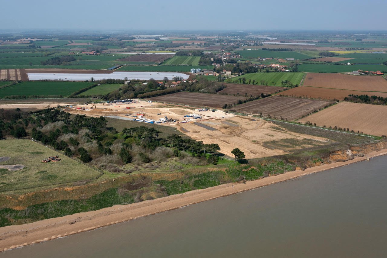
This aerial photograph shows the same landfall process happening at Bawdsey 30 miles away. The image hasn’t been doctored… the cable route is as wide as a motorway.
What’s the alternative?
An offshore grid through the North Sea connected to brownfield sites closer to where the power is needed would create a sustainable, non-invasive solution that can be added to. Our North Sea neighbours in Belgium, Germany, Holland and Denmark are rolling these out… why can’t we?
Who is LionLink?
LionLink is a private company posing as a public one. They are accountable only to their shareholders so are not making decisions that are focused on the public good or the costs they impose on our communities.
Who is WALL?
Walberswick Against LionLink is a local campaigning organisation formed by a group of Walberswick residents opposed to National Grid’s LionLink proposal. It started as a WhatsApp group which grew to have over 230 members. WALL is run by volunteers who are organised through a Steering Group with sub-groups working on Communications, Fund-raising, Environment, Legal, Energy Strategy and other topics.